_Create real value through innovation
We support the complete development of value-added GIS applications and services . In our ongoing technological evolution, we are working in the field of 3D GIS , as well as Virtual Reality, Augmented Reality, and 3D linked to GIS data sources.

Capabilities and services_
We design solutions for our clients' new digital scenarios and the complete development of value-added GIS applications and services .
- GIS Consulting and Development
- Study of graphic data and cartography
- Technical Support (SAT)
- Virtual immersive environments
- Web portals and mobile applications
- Virtual and augmented reality
Trusted by_
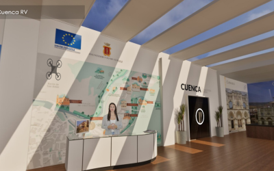
_Generation of products and content
We develop 360 and 3603D interfaces for any application, Virtual Reality tourism offices, virtual museums, virtual environments for e-learning, simulations, virtual stands for companies and any other immersive environment you can imagine .

Multiplatform Viewers: 2D and 3D
We have extensive experience developing multiplatform GIS viewers . By combining graphical and alphanumeric information from various data sources, we visualize and analyze georeferenced data. We incorporate new technologies into Network Analyst for efficient route calculation and intelligent analysis of transportation networks.
Immersive Environments: Virtual Tours and Metaverses
We design and develop immersive environments based on the real world or virtual, in 360 and 360 3D , in which users can move around and interact with the environment or its elements.


3D Modeling. Modeling and 3D
Using the latest 3D modeling techniques and massive data collection with ground equipment and drones, we create high-precision models, with associated BIM information if necessary, that can be used in different types of projects and integrated into GIS applications.
Augmented Reality: Virtual information about the real world
We offer rich digital experiences by overlaying digital information, such as multimedia elements or georeferenced data, over a real-world image . This is achieved through mobile devices or smart glasses , transforming the way we interact with our environment.


Video and photography. 360 and 360/3D
By combining 360/3D/3D 360 video capture with precision GPS location information, we create intelligent georeferenced video work. We use advanced equipment to capture high-resolution, gigaphotographs .